(Balaenoptera acutorostrata) <
/CITE>and beluga or white whales (Delphinapterus leucus) feed in turn on the fish. In late winter through spring, walruses (Odobenus rosmarus) abound in Nunivak waters, feeding on deepwater clams living on the Nunivak shelf. In
a few areas on the Nunivak shore live shallow-water shellfish, especially blue mussels (Mytiluss edulis), littleneck clams (Protothaca staminea?), macoma clams (Macoma sp.?), and surf clams (Spisula polynyma)<
/CITE> (Ackerman, 1988; McConnaughey and McConnaughey, 1985).
Nunivak boasts a dense population of migratory sea birds that also depend directly on marine resources, especially on the steep cliffs forming the southwestern corner of the island. A lack of predators other than foxes (Vulpes fulva) and ermi
ne minks (Mustela ermina), coupled with the large near-shore fish populations make Nunivak a prime rookery for at least 89 bird species. Cliffdwelling species include cormorants (Phalacrocorax sp.), gulls (Xema and <
CITE>Larus
sp.), puffins (Fratercula sp.), shearwaters (Puffinus sp.), murrelets (Synthlibora-mphus sp.), and jaegers (Stercorarius parasiticus). The inland tundra also supports migratory populat
ions of loons (Gavia sp.), grebes (Podiceps sp.), scoters (Melanitta sp.), ducks (Anas sp.), and tundra swans (Cygnus columbianus) (Hoffman 1990, McConnaughey 1985, Udvardy 1977).
Arctic Caribou (Rangifer arcticus) are the only large mammals found archaeologically on Nunivak, but they were rapidly
exterminated in the 1880s by mainland Yupiit people armed with rifles (Lantis, 1986). Euroamericans introduced reindeer (Rangifer tarandus) and musk oxen (Ovibus moschatus)
to the island this century (Griffin, 1996; Lantis, 1996). Rats (Rattus sp.?), voles (Microtus oeconomus), lemmings (Discrostonyx groenlandicus and Synaptomys borealis), shrews (Sorex sp.),
red foxes (Vulpes fulva), and ermine or short-tailed weasels (Mustela ermina) are the only small mammals in the island (Burt and Grossenheider, 1976). Early colonists also brought domestic dogs (Canis familiaris) to
the island (Lantis, 1986?).
Archaeology on Nunivak Island
The earliest documented evidence for human occupation on Nunivak Island appears with Norton Tradition materials (figure 2). BIA investigations on Nunivak recovered materials radiocarbon-dated to 670 B.C. (United States
Bureau of Indian Affairs 1995, in Griffin 1996). At the Mekoryuk Village site, XNI-028, Nowak (1982, 1988) identified two components he termed the Early Duchikmiut Phase (150 B.C. to A. D. 250) and the Late Duchikmiut Phase (A. D. 250 to 650), containing
typologically Norton check-stamped pottery. Nowak (1982: 78 87) described a technological variation between the Early and Late phases. Small-gauge thin walled check-stamped pottery and small ground and chipped lithic tools predominated in the Early phase;
thick-walled large-gauge check-stamped pottery, bone tools, and large ground slate tools (including knives) formed the bulk of the Late phase assemblage. Nowak apparently recovered a large faunal assemblage from Mekoryuk Village, but this assemblage is p
oorly documented. He reports finding hair seal, bearded seal, sea lion, and beluga whale in large quantities at XNI-028. I find the evidence for net fishing technologies at XNI-028 more compelling; Nowak and his crew found more than 1400 notched netsinker
s of uncertain size and function. More than 1000 of these netsinkers appear in the Late Phase, although Nowak believes concentrations of netsinkers in the Late Phase represent caches rather than net remains, with the implication that the greater number of
netsinkers in this phase may not represent the increased use of nets. At
any rate, the large netsinker assemblage suggests an increased reliance on mass fish-harvesting, seal-netting, or bird-netting. Nowak's interpretation of the lack of change in the faunal assemblage from Norton to late historic times indicated to him that
historic Nunivarrmiut have been living in much the same way for more than 2000 years. A paucity of quantified faunal data from Nowak's studies makes fine-tuned assessments of prehistoric Nunivarrmiut subsistence difficult; my research will attempt to redr
ess some of these difficulties.
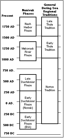
Figure 2, Generalized chronology of archaeological sequences on Nunivak Island (Nowak, 1988) and in the greater Bering Sea region (Dumond, 1987).
Elsewhere on the Bering Sea Alaska mainland, Dumond (1982) sees evidence that Norton peoples organized their subsistence activities around caribou and sea mammal hunting, and riverine fishing. Compared with the Arctic Small Tool tradition (evidence for wh
ich not been discovered on Nunivak Island), mainland Norton sites appear with the establishment of larger, permanent coastal villages, and an increase in fishing and
sea mammal hunting generally (Dumond 1982). An increase in netsinkers in Norton assemblages compared to Arctic Small Tool assemblages and an apparent increase in the intensity of riverine occupations suggest to Lutz (1982) greater exploitation of anadromo
us fish. Dumond (1987: 127) characterizes late Norton peoples as riverine fishers, catching salmon with traps or spears.
Shaw, in his work on the Yukon-Kuskokwim delta, noted netting technologies in assemblages associated with typologically late Norton check-stamped pottery. At MAR-007 on the Manokinak River, Shaw (1983: 118 130, 245 252, 264 265) recovered a single net wei
ght and the remains of a net, in addition to bone fishhooks, dart points, and wooden
fishing implements, including a fish trap and fish clubs. Carved wooden artifacts representing cranes or ducks and a puffin bill decoration reflect an interest at some symbolic or ideological level in birds (Shaw 1983: 156 - 161, 252, 360). Norton settlem
ents on the delta were clustered at coastal localities with protected embayments, on headlands,
or along rivers in the interior uplands (Shaw 1982: 70). Shaw (1982: 71; 1983: 359 - 360) characterizes Norton hunting and fishing as "labor-intensive," relying mostly on large but infrequent takes of each major resource: fish (especially salmon), seals,
and caribou. These three resources form the base of Bockstoce's (1973) "tripartite" economy. If Norton people could rely on at least two of the resources, they could remain well-fed and healthy. But if more than one of the resources collapsed, the people
faced hard times.
The people of the Thule Tradition (after A. D. 1000) seem to have established the classic Arctic lifeway that continued until contact times. Evidence for early Thule occupations appears infrequently on the delta, although this is probably an artifact of t
he lack of archaeological investigation in the region. Shaw (1983) uncovered a late
Norton component he terms the Yukon-Kuskokwim Phase (A. D. 400 1000) from MAR-007, then describes a probable hiatus in occupation from A. D. 1300 to the ethnohistoric present. The late appearance of net technology and bird fauna at the site led Shaw to hy
pothesize that the people at the Manokinak River had adapted net technology for hunting waterfowl
and small terrestrial mammals (Shaw 1982: 71 72). Ethnohistoric data from Nunivak (Hoffman 1990, Pratt 1990) also suggests that cliffdwelling birds had become an important resource for Thule peoples. I would advance the hypothesis that avian resources ad
ded a fourth leg to Bockstoce's (1973) "tripartite" economy, making it generally more stable. By Thule times, Arctic hunters could operate solo or in small groups year-round, instead of relying on more labor-intensive and spatially- and temporally-restric
ted resource exploitation practices.
Researchers have published very little data on Thule occupations on Nunivak Island. Nowak (1988) mentions a potential Thule-era occupation (A. D. 1200) at the Mekoryuk River shell midden site XNI-030, and notes that he identified neither walrus nor beluga
at the site, but that sea lions "appear in small numbers" (Nowak 1988: 46). Nowak (1982) seems to have dismissed the possibility of substantial changes after about
2000 B.P. in Nunivarrmiut subsistence activities, based on his summary analysis of the faunal assemblage from the Mekoryuk Village site, XNI-028.
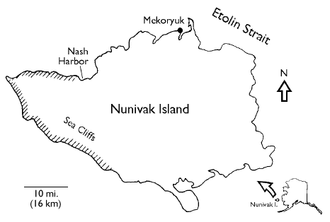
1996 Archaeological Investigations at Nash Harbor
Two former villages are visible at XNI-003 today. NH1 lies on the west side of the Ellikarrmiut River, and is commonly called the "old village," or Ellikarrmiut Village. Nowak's (1988) investigations at the site found evidence for occupation here as early
as 500 years ago. About 100 years ago, an epidemic (probably influenza) at the old village prompted the villagers to relocate across the river to the "new village"
(Griffin, 1996), which I refer to as NH2 (see figure 3). NH1 today is comprised of several deep (1 2 m), distinct house depressions, usually clustered into group houses linked by common entrances. Tall (up to 1.5m) gras
ses cover the entire site, obscuring the surface.
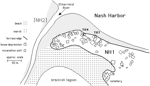
Figure 3, Site map of XNI-003, the Ellikarrmiut site. The later-occupied area NH2 is located west across the Ellikarrmiut river from NH1, and is omitted in this map for clarity.
In 1996, I worked at Nash Harbor with University of Oregon doctoral student Dennis Griffin and Oregon State University master's student Chris Broyles. Griffin also hired five Mekoryuk High School students through a grant from the Summer Youth Training Par
tnership Act Program. Griffin, Broyles, and I were jointly responsible for selecting units for excavation and overseeing the SYTPP workers' screening, survey, and excavations. Broyles and I selected for excavation two shellfish and fishbone middens (TU4 a
nd TU7, see figure 3) visible in the eroding beach bank. Griffin concentrated his efforts on the excavation of house floors, especially near the center of houses where he thought he might find hearths. I also screened displaced slump material
obscuring portions of a beach cutbank profile.
The field crew surveyed the Nash Harbor sites using an optical transit. An arbitrary metric grid was superimposed over the area; all units were laid in using coordinates of this grid. The field crew excavated test units in 10 cm arbitrary levels using tro
wels; slumps were cleared using shovels. The original excavation plan called for screening 3 quadrants of each 1 m square with 1/4" dry screen, and screening the remaining quadrant with 1/8" dry screen. Time and labor pressures forced us to abandon this s
trategy in favor of 1/4" screening all material from a provenience, and retaining a 2 liter bulk sample from the general provenience. Additional bulk samples of midden materials were retained,
as were discrete charcoal samples for 14C dating. Worked tools and other finished artifacts found during excavation were recorded and catalogued seperately from the general screen sample, and recorded in situ where possible.
At least one wall was profiled from every finished test unit, and soil samples were retained from most profiled strata. I also made a sketch profile of the exposed beach cutbank in order to target midden areas that might prove useful for faunal research,
and refined my sketch profiles in two areas of the beach to help fix stratigraphic sequences for nearby test units. Soils were mapped with a methodology that favored identification of buried surfaces and depositional episodes. Major depositional sequences
are designated with Roman numerals; substrata that may represent single depositional episodes within the stratum are designated with Arabic numerals. Therefore, stratum III-1 indicates the first identified substratum in major stratum III.
My master's work will concentrate on study of the faunal materials from two midden areas at the old village site, NH1. Preliminary stratigraphic profiles made on the eroded beach face identified several discrete midden areas that could yield a wealth of f
aunal material for study. I identified two middens for excavation and laid out units in each.
Test Unit 4 (TU4) is located just outside feature 58, an entryway to a large house complex. Extensive middens of fish, bird, and mammal bone were eroding from the cutbank in this area, and several large flat rocks and wooden timbers suggested that the uni
t might also contain buried structural members.
Excavation of TU4 began at the top of the beach exposure. At around 50 cm below surface, we encountered frozen soil and were forced to abandon excavation. We opened a second test unit (TU5) immediately south of TU4, hoping to stagger excavation of TU4 and
TU5 to allow the soil to thaw. The rates of thaw proved too slow, however, so I concentrated my excavations in TU4, which had thawed about 50 cm back from the edge of the bank.
Around 160 cm below surface, we encountered several large, flat rocks stacked two to three deep. None of these large rocks showed evidence of having been grinding stones or hearth stones; we conjectured that they may have been "flagstones" lining the floo
r of a food cache or sauna. This collection of rocks was dubbed "Feature 1," and divided the excavation of TU4 into two vertical sections, top and bottom. Several of the stones proved too large to remove without damaging the excavation unit walls, and wer
e left in situ with a thick pedestal underneath. Permafrost, Feature 1, and the depth of the unit conspired to make TU4 somewhat less than ideal in shape (Figure 4).
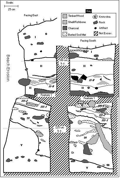
Figure 4, Generalized stratigraphic profile of the south and east walls of TU4. Most substrata have been omitted for clarity.
I propose a division of the cultural sequence reflected in TU4 into at least 3 distinct
episodes. In the first episode, a house (stratum IV) is constructed atop beach sands (stratum V). This lowest occupation horizon is the best likely candidate for a Norton habitation, although with a lack of diagnostics and 14C dates from stratum IV, I can
advance this only as speculation. The house was eventually abandoned and collapsed, and was covered by a layer of windborne sand (substratum III-1) and some cultural debris (substratum III-2), which may be associated with
the construction in the second episode of the mysterious Feature 1. In the third episode, people living in the nearby house complex heaped trash on top of Feature 1 (stratum II).
Unlike TU4, Test Unit 7 (TU7) may not be clearly associated with an extant house structure. It sits about four meters east of an opening to a small house complex that was truncated by beach erosion. TU7 is probably associated with this feature or with a h
ouse that has eroded entirely into the sea. Structural members visible in the bank about eight meters east of the midden may be all that remain of this conjectured dwelling.
TU7 proved relatively shallow and free of permafrost. A lens of mussel and clam shell and some fishbone was visible from the beach; sketch profiles and slump clearing revealed a single intact midden that might prove fruitful for faunal research. Like TU4,
TU7 has an irregular shape due to the contour of the beach bank; the unit was extended in the northwest corner to reach the edge of the bank 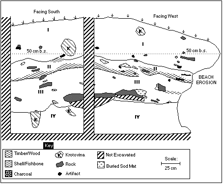
Figure 5, Generalized stratigraphic profile of the west and south walls of TU7. Most substrata have been omitted for clarity.
The stratigraphy of TU7 probably represents no more than 2 occupational episodes. In the first episode (stratum III), Ellikarrmiut people probably performed some outdoor activity, probably shellfish or plant processing, directly on beach sands. Alternatel
y, the area may have been a thin trash area, not an activity site. The conjectured break between substrata III-1 and III-2 may represent a brief hiatus of activity.
In the second episode, Ellikarrmiut people deposited shellfish debris (stratum II). Although a stable surface may bound the top of stratum III, very little time may have elapsed between the deposition of stratum III and stratum II materials. Undecorated,
thick-walled pottery found in TU7 suggests that the entire midden is recent, probably late Thule (less than 500 years ago) in age.
Research Questions and Goals
Analyses of the faunal materials from the TU4 and TU7 middens will help me address several questions concerning the diet and subsistence patterns of the Ellikarrmiut people. Analyses of the spatial/temporal distribution of taxon/element pairs, when corrob
orated with geoarchaeological analyses and 14C dates, will allow me to ask the following questions:
- What is the variation between depositional episodes within each midden, especially in TU4?
- What are the general subsistence patterns at Ellikarrmiut Village (collapsing the temporal dimension for clarity)? That is, through all time periods, which foods were important in the diet of Ellikarrmiut residents?
- What is the variation in subsistence patterns at each midden through time? This may be especially relevant in the deep sequence found in TU4.
- What is the morphology of cultural features in TU4 below Feature 1? At this point I suspect that Feature 1 "caps" a buried earlier cultural sequence; this lower sequence may represent part of a buried house structure.
I can also utilize the results of temporal/spatial analyses, corroborated with oral-historical,
ethnohistorical, and independent archaeological studies to address questions of cultural
continuity and change at Ellikarrmiut Village:
- How do subsistence patterns reflected at Ellikarrmiut Village change from Norton or Early Thule times to Late Thule times? How does this compare with data from other sites in the Alaskan Bering Sea region?
- What activities are represented in each midden, especially if they prove to be nearly contemporaneous?
- To what degree can we rely upon oral historical data to construct hypotheses or derive inferences about past behavior at NH1? How can we control for and explain discrepancies between the ethnographic/oral historic record and the archaeological record?
- What are the general and proximate causes of subsistence pattern changes in time, such as changes in hunting/fishing technologies, or changes in human and animal populations?
- How did contact with Russians and Americans in the 19th century affect the faunal material distribution patterns in the middens? What agents are responsible for this variation, and to what degree: The epidemics of the late 19th century? Increasing fur
trade and introduction of traded foods? Extinction of local caribou herd around 1880? Introduction of reindeer and musk ox in the 20th century?
Research Strategies
The analysis of faunal remains from the TU4 and TU7 middens will operate on several strategic levels concurrently. These levels are not mutually exclusive, and in general the operation of later stages is not contingent upon the completion of earlier stage
s. The operational directive of my research design is flexibility: altering later-stage analyses and inferences based on work actually completed. For clarity, I will identify four stages of analysis, outlined below.
Stage 1: Clean and Sort Screen Samples
The first stage of analysis focuses on the processing of screened materials from throughout the site. I have targeted the TU7 and TU4 middens as priority areas, so that I expect that these materials will be cleaned and sorted into broad material classes b
y early January, 1997. In Stage 1, laboratory workers clean screen samples from targeted
proveniences with dry natural fiber brushes and damp natural sponges. They then sort the samples into seven broad materials classes: stone tool fragments/debitage, pottery, charcoal/botanical material, historic debris, shell, fish bone, and other bo
ne (mammal and bird). Finally, laboratory workers weigh the material in each class and count individual specimens. I then enter these weights and counts into an Excel spreadsheet to track the relative abundance of faunal material classes within and
between proveniences. I will use this spreadsheet to target proveniences with large and variable amounts of faunal material for my Stage 2 discretionary sample.
In practice, Stage 1 must be nearly complete before any later-stage analyses can proceed, although Stage 1 work can continue as I analyze material that has already been cleaned
and sorted.
Stage 2: Identify Elements within Discretionary Samples
Using geoarchaeological data (see Site Structure, above) and the graphs of relative abundance from Stage 1, I will select 2 to 4 excavation levels from each unit for Stage 2 analysis. Within especially large samples, I may resort to a random
subsample of the discretionary sample--probably 25% to 50%, with the materials chosen by a random selection strategy. I will identify the anatomical element and the finest possible taxon of each specimen in each subsample,
and weigh the specimens. For fish and bird taxa, it may be possible to record weight, taxon and element data for each specimen individually; with the large amount of shell materials, I may resort to bulk reporting of weights by taxon/element. Finally, I w
ill process bulk samples associated with some taxonomically diverse Stage 2 proveniences, with the hope of controlling for the loss of small specimens in the field due to 1/4" screen recovery techniques. I will enter the data derived from Stage 2 and
Stage 3 analysis into a dBase III+ database, then use this database to construct Number of Individual Specimens (NISP) indices for each taxon/element pair. From NISP indices, I can derive estimates of Minimum Number of Individuals (MNI) of each taxonomic
group,
and plot the relative spatial distribution of the number of animals of each taxon. With geoarchaeological and 14C dating information, I can begin to answer basic questions about animal product use at Nash Harbor (research questions 1 and 2), and its chang
e through time (research
question 3). Sea mammal bones, for example, may be represented throughout both middens, but certain areas may contain more numbers of individuals of a single taxon, while other areas may have a greater diversity of taxa. In Stage 2, I can also begin to an
alyze the activities represented at each midden (research question 6). For example, the TU7 midden may have such a preponderance of shellfish of a single species, to the exlusion of other kinds of materials, that I might postulate that it represents a she
llfish processing station or a single episode of shellfish processing.Stage 2 analysis must be completed or nearly completed before Stage 3 and Stage 4 analysis can proceed.
Stage 3: Identify Elements in Stratified Random Sample
In Stage 3, I will identify specimens in arbitrarily-selected proveniences. In actual terms, this will probably involve analyzing samples from alternate levels, or from random levels within stratagraphic units. The method for deriving my Stage 3 sample wi
ll proceed from the amount of Stage 2 analysis that I have conducted by certain date, probably mid-February, 1997. If Stage 2 is largely complete before this date, my Stage 3 sample will be larger than if Stage 2 work has bogged down by February. Within
each Stage 3 sample, I will identify each specimen to element and most specific taxon, and record their weights (as described in Stage 2). As in Stage 2, I may also process a proportion of each bulk sample to help control for data lost through broad field
recovery. I will also expand my MNI and NISP indices as the primary data set grows.
If time and labor permit, I will expand the Stage 3 sample to include a larger proportion of the total faunal sample from the TU4 and TU7 middens. For example, if I have identified all Stage 2 and 3 materials by early March, I may expand the Stage 3 sampl
e to 75% of all material, using the same sampling technique with which I derived earlier Stage 3 material. In theory, this may lead to total identification of all specimens from the faunal sample from both middens. In practice, total or near-total coverag
e may not be possible without the assistance of work-study or volunteer students in Stage 2 and Stage 3 analysis.
Data from Stage 3 work will allow me to refine and expand spatial distribution analyses begun in Stage 2. The addition of stratigraphically-selected data in particular will help me fix the variation of animal product use through time. I will also refine
my description of the cultural activities represented at each midden, and address the purpose of Feature 1 in TU4 and the possible house fill underneath it (research questions 4 and 6).
Stage 3 analysis can proceed as Stage 2 analysis is finished, and can continue while I conduct Stage 4 analysis and synthesis. I will probably begin my statistical spatial analyses while finishing Stage 3 work.
Stage 4: Spatial Data Analysis; Synthesis
From the database generated during Stages 2 and 3, I will conduct spatial distribution analyses of faunal materials within and between the TU4 and TU7 middens. By this time (probably early in Spring Term, 1997), I hope to have geoarchaeological data and 1
4C dates that will help me fix a temporal scale to the data. Spatial analyses will include distributions of material types within each midden, and their temporal implications; I will also conduct simple regression analyses to derive covariance of taxon/el
ement groups.
While much of the Stage 4 analyses will, of necessity, be quantitative and statistical in nature, I hope to incorporate qualitative syntheses of the data as well. I will review oral histories and ethnographic literature to infer symbolic and socioeconomic
meanings of food animals, and the changes in those animals' use through time.
Data from the covariance of specific taxon/element pairs and a well-established temporal sequence will allow me to address more difficult research questions. If I can firmly establish certain patterns of resource use through time (the decline of utilizati
on of one resource concurrant with the increased use of another, for example), then
I can review ethnohistoric and archaeological literature to suggest explanations for why this may be so. If changes in resource use occur very late in the cultural sequence--during the late 19th century or after--then I will also consider the influence of
contact with Russians and Americans on Ellikarrmiut people. For example, I may find a rise in Vulpes remains associated with a decline in shellfish and the introduction of historic metal debris. This may suggest that the fur trade had allowe
d Ellikarrmiut people to acquire foodstuffs from elsewhere that may have replaced shellfish in importance.
Significance of Research
The archaeological database from Nunivak Island, like that of most of the Yukon-Kuskokwim delta region, suffers from a lack of excavation-derived data, and a scarcity of data generally. To the best of my knowledge, no systematic faunal analyses of any kin
d have been attempted on material from Nunivak Island sites. Any contribution to the
archaeological record of the region will provide insight into questions of resource exploitation changes through time. In particular, faunal studies can potentially answer questions about the proposed expansion of the Norton resource base with the rise of
the Thule pattern. My research can also help illuminate relationships between Nunivarrmiut Cupiit and Americans during the contact period, as reflected in changes in subsistence and the expansion of the fur trade.
Griffin (1996) has addressed the important social benefits that archaeological research at Nash Harbor can provide for the people of Nunivak Island, who, like most people, display an interest in the history of their land. In the hope of nurturing this int
erest, we will publish some of our research on a World Wide Web site, and share our
written work with people in Mekoryuk. In this way, I hope to serve as an advocate for the study of the island's history in a cooperative environment with the people
of Mekoryuk.
The last inhabitant of Nash Harbor left the village for residence in Mekoryuk in 1957 (Griffin 1996), but Nash Harbor continues to play a role in the lives of Nunivak Islanders as the site of a commercially-important reindeer corral, and as a good place f
or muskox hunting, salmon fishing, sealing, and collecting greens. Although Nash Harbor has no permanent residents today, it remains in this sense a living community. As with any other place, the study of Nash Harbor's story is a worthy goal in and of its
elf.
Research Timeline
~Jan. 1 7, 1997
- Return of first batch of 14C dates.
- Finish Stage 1 (clean & sort).
- Select discretionary samples for Stage 2.
- Begin Stage 2: analyze discretionary sample.
~Feb. 21, 1997
- Finish Stage 2. Select stratified random sample for Stage 3.
- Begin Stage 3: analyze stratified random sample.
Mar. 21, 1997(End of winter term.)
- End Stage 3 work.
- Finish geoarchaeological analysis: site formation, structure of TU4 below Feature 1.
Mar. 31, 1997 (Beginning of Spring term.)
- Begin Stage 4 (synthesis): spatial distributions, covariance
of taxon/element pairs.
April, 1997
- Begin writing paper: background sections, spatial analyses.
- Possible return of more 14C dates sometime in April (?)
~May 5, 1997
- Finish Stage 4 analysis: address middle-range questions; generate oral historical/ethnohistorical
syntheses with faunal data.
May 12, 1997 (Three weeks before end of Spring term.)
- Present 1st draft of paper.
late May, 1997
- Revise 1st draft.
June 3, 1997
- (One week before end of Spring term.) Present final draft.
Selected Bibliography
(* = Indicates cited reference)
- Ackerman, Robert E.
- 1988 Settlements and Sea Mammal Hunting in the Bering-Chukchi Sea Region. Arctic Anthropology
24(1):55 - 79
- Bockstoce, John
- *1973 A Prehistoric Population Change in the Bering Strait Region. Polar Record
16:793 - 803.
- Burt, William H. and Richard P. Grossenheider
- *1976 A Field Guide to the Mammals, North America North of Mexico. The Peterson Field Guide Series, New York: Houghton Mifflin.
- Dumond, Don
- *1982 Trends and Traditions in Alaskan Prehistory: The Place of Norton Culture. Arctic Anthropology
19(2):39 - 51
- 1986a "Prehistory of the Bering Sea Region," in The Handbook of the North American Indian, vol. 5: The Arctic,
David Damas, ed. pp. 94 - 105. Washington: Smithsonian.
- 1986b "Prehistory: Summary," in The Handbook of the North American Indian, vol. 5: The Arctic,
David Damas, ed. pp. 72 - 79. Washington: Smithsonian.
- *1987 The Eskimos and Aleuts.
London: Thames and Hudson, Ltd.
- Dumond, Don E., and Richard L. Bland
- 1995 Holocene Prehistory of the Northernmost North Pacific, Journal of World Prehistory
9(4):401 - 451
- Griffin, Dennis
- *1996 Portrait of Nash Harbor: Prehistory, History, and Lifeways of an Alaskan Community. Dissertation prospectus, on file at Dept. of Anthropology, Univ. of Oregon, Eugene.
- Hoffman, Brian W.
- *1990 Bird Netting, Cliff-Hanging, and Egg Gathering: Traditional Procurement Strategies
on Nunivak Island. Arctic Anthropology
27(1): 66 - 74.
- Lantis, Margaret
- 1946 The Social Culture of the Nunivak Eskimo.
Philadelphia: Transactions of the American Philosophical Society, new series, vol.35,
pt.3.
- *1986 "Nunivak Eskimo" in The Handbook of the North American Indian, vol. 5: The Arctic,
David Damas, ed. pp. 209 - 223; 105. Washington: Smithsonian.
- Lutz, Bruce J.
- *1982 Population Pressure and Climate as Dynamics within the Arctic Small Tool Tradition
of Alaska. Arctic Anthropology
19(2):143 - 149
- McConnaughey, Bayard H. and Evelyn McConnaughey
- *1985 Pacific Coast.
The Audubon Society Nature Guides, New York: Alfred A. Knopf, Inc.
- Nelson, Edward William
- 1899 The Eskimo About Bering Strait
. Bureau of American Ethnology, vol. 18 pt. 1
- Nowak, Michael
- *1982 The Norton Period of Nunivak Island: Internal Change and External Influence.
Arctic Anthropology
19(2):75 - 91
- *1988 Sea Mammals in a Mixed Economy: A Southwestern Alaskan Case. Arctic Anthropology
25(1): 44 - 51.
- Pratt, Kenneth L.
- *1990 Economic and Social Aspects of Nunivak Eskimo "Cliff-Hanging." Arctic Anthropology
27(1):75 - 86
- Shaw, Robert D.
- *1982 The Expansion and Survival of the Norton Tradition on the Yukon-Kuskokwim Delta.
Arctic Anthropology
19(2):59 - 73
- *1983 The Archaeology of the Manokinak Site: A Study of the Cultural Transition Between
Late Norton Tradition and Historic Eskimo.
PhD dissertation, Dept. of Anthropology, Washington State University.
- Shaw, Robert D. and Charles E. Holmes
- 1982 The Norton Interaction Sphere: An Orientation. Arctic Anthropology
19(2):3 - 10
- Udvardy, Miklos D. F.
- *1977 The Audubon Society Field Guide to North American Birds, Western Region.
New York: Alfred A. Knopf, Inc.
- United States Bureau of Indian Affairs, ANCSA Office
- 1995 Nunivak Overview: Report of Investigations for BLM AA-9238 et al. 6 volumes.
Kenneth L. Pratt, compiler, editor, and principal author. Copy on file, BIA ANCSA
Office, Anchorage, Alaska.
- VanStone, James W.
- 1989 Nunivak Island Eskimo (Yuit) Technology and Material Culture. Fieldiana/Anthropology
n.s. 12. Chicago: Field Museum of Natural History
Copyright © 1997, Paul Souders
psouders@europa.com